



Covering approximately 390 hectares, the Kiemerchen / Scheiergronn / Groussebësch core zone has been designated as a national nature reserve since 2019. It stretches for around six kilometres from Soleuvre through Oberkorn to Belvaux and runs alongside the French border for almost its entire length.
Like the other core zones of the Minett UNESCO Biosphere, this area has been strongly shaped by the former extraction of Minette iron ore. In Kiemerchen and Scheiergronn in particular, iron ore was mined in open-cast pits until the 1970s.
A Landscape Shaped by Open-Cast Mining
Former mining activities have left clearly visible traces in Kiemerchen and Scheiergronn. Rock faces, escarpments, old open-cast mining areas and transport routes still bear witness to a time when iron ore shaped both the landscape and everyday life in the region.
A particularly striking feature is the approximately three-kilometre-long paved haul road. It was once used to transport Minette iron ore directly to the nearby steelworks. Today, the route provides a convenient connection for walkers, hikers and cyclists crossing the nature reserve.
The road is therefore a good example of the transformation undergone by the entire core zone. Former industrial infrastructure has acquired a new purpose and now enables visitors to experience the area’s natural and mining heritage.
Following the end of open-cast mining, nature gradually reclaimed the former extraction sites. Pioneer plants first established themselves on the open ground. Grasslands, shrubs and young forests then began to develop. These different stages of natural succession now form a mosaic of habitats with exceptional value for biodiversity.
Groussebësch: A Woodland Area in the Crosnière Valley
Groussebësch is separated from the other parts of the protected area by the CR174 road and several fields. It is located near Lasauvage, in the valley of the Réierbaach stream, also known as the Crosnière.
This part of the core zone consists mainly of a large, continuous woodland area. However, several small former open-cast mining sites can also be found here, recalling the area’s mining history.
One of these sites was cleared of scrub in October 2021. Opening up the site is intended to preserve and create suitable habitats for lizards and rare orchids. This measure illustrates how certain species depend on open, sunny areas and how targeted management can be necessary to prevent these valuable habitats from becoming completely overgrown.
Groussebësch is served by several woodland paths. One of the best ways to discover the area is by following the Crosnière Trail, which runs alongside the Réierbaach through the Lasauvage valley.
Exceptional Biodiversity at the Heart of the Minett
The Kiemerchen / Scheiergronn / Groussebësch core zone is characterised by an extraordinary diversity of habitats. Pioneer forests, dry grasslands, open rocky areas, former quarries, ponds, temporary pools, and old mine galleries provide refuge for a wide variety of plant and animal species.
Particularly remarkable is the wealth of orchids. In spring, visitors may encounter Cung’s marsh orchid (Dactylorhiza incarnata ssp. cungsii), a rare orchid that occurs nowhere else in the world. Another striking species is the bee orchid (Ophrys apifera), which adds colour to the landscape during the flowering season.
|
|

© Marc Weis
Alongside the orchids grows the legally protected common centaury (Centaurium erythraea). These plants thrive in the nutrient-poor, open, sunlit conditions that developed after mining ended.
The dry grasslands and varied stages of vegetation development also provide ideal habitats for numerous butterfly species.
Rock Faces, Mine Galleries and Ponds as Habitats
The landforms created by mining now play an important ecological role.
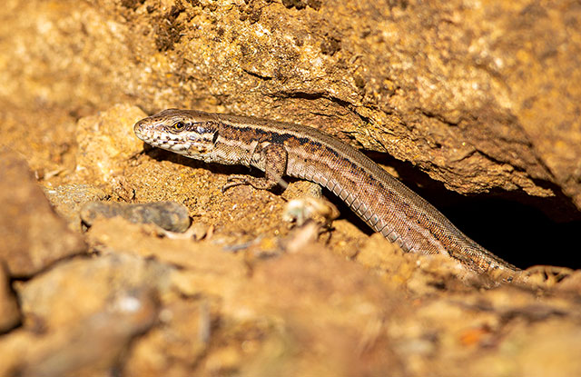
Sunny cliffs and exposed rocky outcrops offer lizards sheltered places where they can bask and regulate their body temperature. The underground mine galleries beneath former mining areas serve as important habitats for bats.
The reserve’s ponds and temporary pools are equally significant. They provide breeding sites for the natterjack toad (Epidalea calamita), known in Luxembourgish as the Onk. This amphibian species is considered endangered in Luxembourg.
The combination of dry, sunny habitats and moist environments is what gives this core zone its exceptional ecological quality. Within a relatively small area, species with very different environmental requirements are able to coexist.
Exploring the Core Zone on Foot or by Bicycle
Because of its size, the core zone can be explored through a network of trails and routes.
The former truck road provides an easy route across the reserve. Where heavy vehicles once transported iron ore, hikers, walkers, and cyclists now travel through newly established forests and natural habitats.
The Sentier de la Crosnière is particularly recommended for discovering Groussebësch and the Réierbaach valley. The trail follows the stream that shaped the Lasauvage valley and leads visitors through extensive woodland habitats.
Other possibilities include:
- the Auto-Pédestre Déifferdeng walking trail;
- the CFL Hiking Trail 27 between Belvaux-Soleuvre and Oberkorn;
- the CFL Hiking Trail 28 between Oberkorn and Niederkorn.
These routes offer different perspectives on the core zone and connect natural habitats with the visible remains of former iron ore extraction.
A Landscape Actively Managed for Conservation
Although nature has reclaimed much of the former mining landscape, this does not mean the entire area can be left entirely to natural processes.
Many rare plants and animals depend on open, sunny, nutrient-poor habitats. If these areas become completely covered by shrubs and forest over time, the specialised species that rely on them, including orchids, lizards, butterflies, and many others, would disappear.
The clearing of a former mining area in Groussebësch in October 2021 is an example of targeted conservation management. Such measures help preserve open habitats and maintain their characteristic biodiversity over the long term.
The core zone is therefore more than a landscape reclaimed by nature. It is also a place where different stages of this ecological transformation are deliberately protected and managed.
 |
 |
 |
© Yann Logelin / Jan Herr / Marc Weis
What Can Be Discovered Nearby?
E Besuch vun der Kärzon léisst sech mat verschiddene Plazen an der Ëmgéigend kombinéieren.
Lasauvage
Located in the Réierbaach valley, Lasauvage is the ideal starting point for exploring Groussebësch and the Sentier de la Crosnière. The village and its surroundings are closely linked to the region’s mining history.
The Réierbaach (Crosnière) Valley
The Réierbaach, also known as the Crosnière, shaped the Lasauvage valley. The Sentier de la Crosnière follows the stream through the extensive forests of Groussebësch.
Differdange and Oberkorn
Several hiking routes connect the core zone to Differdange and Oberkorn. The Auto-Pédestre trail and the CFL hiking paths make it possible to explore the reserve from different access points.
Belvaux and Soleuvre
At its eastern end, the core zone reaches the surroundings of Belvaux and Soleuvre, including the impressive Zolwerknapp hill. From here, visitors can also access walking routes that allow them to discover the landscape on foot.
The Youngest Protected Area of the Minett UNESCO Biosphere
Kiemerchen, Scheiergronn, and Groussebësch provide an excellent example of how closely nature and mining heritage are connected throughout the Minett region.
The former quarries, cliffs, mine galleries, and transport routes have not disappeared. They remain visible elements of the landscape while simultaneously providing the foundation for new habitats.
Rare orchids now grow on former mining grounds. Bats find shelter in old mine galleries. Rock faces provide suitable conditions for lizards, while ponds and temporary pools support endangered amphibians. The former truck road has become a route for hikers, walkers, and cyclists.
This core zone perfectly embodies a central idea of the Minett UNESCO Biosphere: protecting nature, preserving the visibility of industrial heritage within the landscape, and enabling people to discover and appreciate both in a respectful and sustainable way.